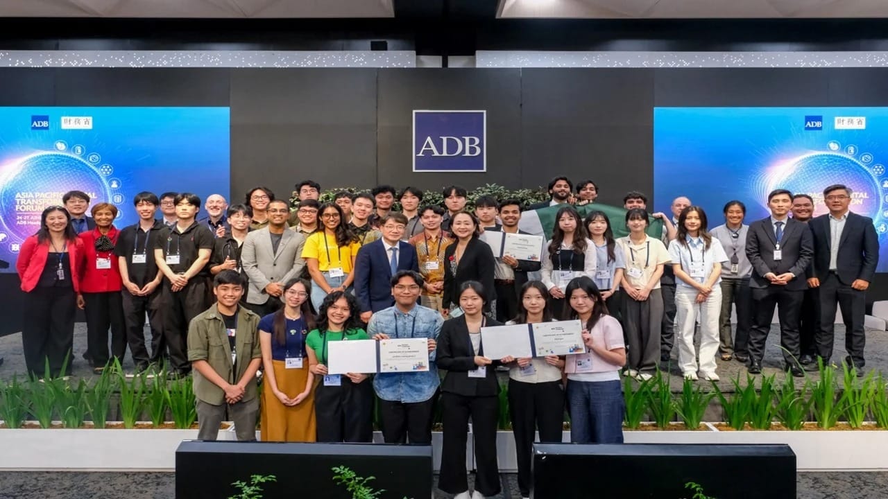
Pakistani Students Win Global Award for Geospatial AI Innovation
Two brilliant students from Islamabad’s Institute of Space Technology, Ahmed Iqbal and Hanzila Bin Younas, have placed Pakistan on the global innovation map. Their groundbreaking project, GeoGemma, is an open-source Geospatial AI solution built on Google Earth Engine. This remarkable innovation won the Best AI Use Case award at the APAC Solution Challenge 2025 in Manila, Philippines.
With the power of Geospatial AI, GeoGemma aims to democratize access to satellite imagery and geospatial data, enabling researchers, developers, and communities to use advanced technology for solving real-world challenges such as climate change, urban planning, and disaster management.
The Rise of Geospatial AI
What is Geospatial AI?
Geospatial AI is the fusion of artificial intelligence and geospatial technologies such as satellite imagery, remote sensing, and mapping platforms. It enables automated analysis of massive data sets to identify patterns, predict outcomes, and support decision-making.
From agriculture and environment monitoring to disaster response and smart cities, Geospatial AI has become a key driver of next-generation innovation.
GeoGemma: A Student Innovation That Made History
Ahmed Iqbal and Hanzila Bin Younas began GeoGemma as their final-year project at the Institute of Space Technology in Islamabad. What started as an academic exercise evolved into a project with international recognition.
Their vision was simple but ambitious:
- Make geospatial data more accessible through an open-source platform.
- Integrate AI with Google Earth Engine to analyze satellite imagery.
- Provide affordable and scalable solutions to researchers, NGOs, and governments.
The project’s success earned them not only the APAC award but also a $10,000 development grant, giving GeoGemma the boost it needed to scale further.
How Geospatial AI Powers GeoGemma
GeoGemma uses Geospatial AI to process satellite imagery in real-time and make sense of complex patterns. Its applications are far-reaching:
- Disaster Management: Predicting flood-prone zones and mapping earthquake impact.
- Agriculture: Monitoring crop health, water distribution, and soil conditions.
- Urban Development: Assisting planners in managing city growth and smart infrastructure.
- Climate Change: Tracking deforestation, glacier melting, and carbon emission zones.
By being open-source, GeoGemma ensures accessibility for students, researchers, and policymakers in developing countries who otherwise lack costly proprietary tools.
Global Recognition and Google’s Attention
The Geospatial AI project did not just impress judges at the APAC Solution Challenge; it also caught the attention of Google DeepMind, one of the world’s leading AI research labs.
The recognition from DeepMind highlights the potential impact of GeoGemma in global geospatial research. With AI giants acknowledging its value, GeoGemma is poised to evolve into a tool that could benefit international organizations, humanitarian efforts, and climate-focused initiatives.
Why Pakistan’s Victory in Geospatial AI Matters
For Pakistan, this recognition is more than just an award—it’s proof that the country can compete in the Geospatial AI and artificial intelligence domains at a global level.
- Showcases Talent: Pakistani students have the skills to innovate on a world stage.
- Boosts STEM Education: Encourages universities to invest in AI and space technologies.
- Attracts Global Partnerships: Opens doors for collaborations with tech giants like Google.
- Inspires Youth: Motivates thousands of students to explore careers in AI and space research.
The Future of Geospatial AI in Pakistan
GeoGemma represents the beginning of Pakistan’s journey into Geospatial AI. With increased government focus on technology and innovation, projects like this can be scaled to:
- Improve national disaster management systems.
- Support sustainable agriculture.
- Enhance defense and space research.
- Create new job opportunities in the AI ecosystem.
As more universities encourage student-led projects, Pakistan could emerge as a hub for AI-driven geospatial research in South Asia.
Examples of Geospatial AI Applications
To understand the power of Geospatial AI, here are real-world examples:
- NASA’s Earth Observing System uses satellite data to track global climate change.
- UNICEF applies AI-based geospatial tools to identify regions in need of humanitarian aid.
- Smart Cities Projects in Singapore and Dubai integrate geospatial data for efficient transport and resource management.
- GeoGemma now joins this global ecosystem by making advanced analysis tools more accessible to developing countries.
Challenges in Developing Geospatial AI
While the success of GeoGemma is inspiring, the field of Geospatial AI comes with challenges:
- Data Accessibility: Satellite imagery is often expensive and restricted.
- High Computing Power: Processing geospatial data requires advanced hardware.
- Policy Gaps: Many countries lack AI regulations for satellite data usage.
- Skill Shortage: Few experts are trained in both AI and geospatial technologies.
Overcoming these challenges will be crucial for GeoGemma and similar projects to expand globally.
FAQs About Geospatial AI and GeoGemma
Q1: What is Geospatial AI in simple terms?
Geospatial AI is the use of artificial intelligence to analyze satellite imagery and geographic data for solving real-world problems.
Q2: Why is GeoGemma important?
GeoGemma democratizes access to geospatial data, making advanced tools affordable for developing nations.
Q3: Who developed GeoGemma?
Two Pakistani students, Ahmed Iqbal and Hanzila Bin Younas, from the Institute of Space Technology.
Q4: What award did GeoGemma win?
It won the Best AI Use Case award at the APAC Solution Challenge 2025 in Manila.
Q5: How is Google involved in GeoGemma?
Google DeepMind has shown interest, and the project received a $10,000 grant for development.
Conclusion
The story of GeoGemma is not just about an award—it’s about the rise of Geospatial AI in Pakistan. Ahmed Iqbal and Hanzila Bin Younas have shown the world that innovation can come from anywhere, and their success serves as a beacon of hope for the country’s future in science and technology.
As GeoGemma grows with global support, it could become a tool that transforms climate research, disaster management, and urban development across the world. Pakistan’s entry into the world of Geospatial AI is just the beginning, and the future looks promising.
Read More Here:
Free Online Courses from Harvard & Google for Pakistanis 2025